
Gusty Winds, Periods of Heavy Rain and Coastal Flooding
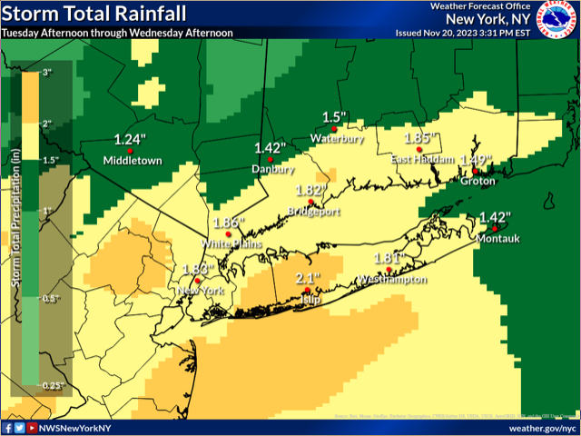
· Rainfall and Flooding: Beginning Tuesday afternoon, there is a likelihood of rain increasing by mid afternoon into the early evening. Total rainfall from late Tuesday afternoon through Wednesday morning is expected to be a widespread 1 to 2 inches. This could lead to minor or nuisance flooding, with the heaviest rainfall expected after midnight Tuesday into early Wednesday. Flash flooding is not expected at this time.
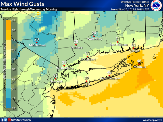
· Wind Conditions: Late Tuesday night into early Wednesday morning, gusty winds are expected, particularly along coastal areas. Gusts in the 30-40 mph range are possible, particularly near the coast. Gusts across far eastern Suffolk County could briefly reach 45-50 mph. This could lead to some wind-related impacts such as downed trees or power lines mainly across the coastal areas.
· Coastal Flooding: Confidence is increasing for a widespread minor coastal flood event during the morning high tide cycle Wednesday. Strong southeast winds overnight Tuesday into Wednesday morning will produce a surge that may raise water levels by as much as 2 to 3 feet. Tides are astronomically low at this time, which will keep the flood threat mainly minor. However, some of the south shore back bays of western Long Island may experience localized moderate flooding. In addition, heavy rainfall coinciding with high tide and wave action along the Connecticut coastline could enhance the coastal flood threat. Locations particularly at risk include the South Shore Bays of Long Island and the southwest Connecticut coast. Areas along upper NY Harbor and the north shore of Long Island may only see localized minor coastal flooding.
